
Austin is known for its blend of natural beauty and urban character, making it a compelling city for aerial photography. For enthusiasts and professionals alike, Austin aerial photography captures rolling hills, winding waterways, and a modern skyline that offer diverse perspectives from above. From iconic bridges to expansive parks, several locations consistently stand out for their visual appeal and compositional value.
Lady Bird Lake and the Downtown Skyline
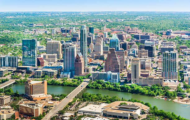
Lady Bird Lake is one of the most Austin aerial photography, especially from elevated viewpoints. The lake runs through the heart of the city, allowing aerial images to capture water, greenery, and the downtown skyline in a single frame. Early mornings often provide calm water and soft light, while evenings bring dramatic reflections and illuminated buildings. From above, the contrast between natural elements and dense urban development creates a balanced and visually striking composition.
Mount Bonnell and Surrounding Hill Country
Mount Bonnell sits at a higher elevation than much of the city and offers sweeping views of the surrounding landscape. Aerial perspectives in this area highlight the curves of the Colorado River, residential areas nestled into hills, and expansive tree cover. The terrain adds depth and dimension, especially when captured during sunrise or sunset, when shadows emphasize elevation changes and natural contours.
Pennybacker Bridge (360 Bridge)
Pennybacker Bridge is one of Austin’s most recognizable structures. Its arched design crossing over Lake Austin creates strong geometric lines that translate well into aerial imagery. From above, photographers can capture the bridge as a central focal point, framed by water and rolling hills. Seasonal changes also influence the look of this area, with water levels and foliage color altering the overall visual tone throughout the year.
Zilker Park and Lou Neff Point
Zilker Park provides wide-open green spaces near the city center, offering a different perspective from Austin’s vertical skyline. Aerial views often reveal walking paths, event lawns, and the surrounding tree canopy. Nearby Lou Neff Point is known for its clear vantage toward downtown, making it ideal for aerial shots that frame the skyline against the lake. The combination of parkland and city structures creates a dynamic visual contrast.
Barton Creek and Natural Landscapes
Beyond the city’s architectural landmarks, Austin’s natural areas are equally popular for aerial photography. Barton Creek and nearby greenbelt areas feature limestone formations, winding trails, and dense vegetation. These locations are particularly appealing for aerial compositions that emphasize organic shapes and textures rather than structured urban layouts.
Conclusion
Austin’s varied geography and recognizable landmarks make it an excellent setting for aerial photography. From lakes and bridges to elevated viewpoints and natural corridors, the city offers diverse visual opportunities. Whether highlighting urban growth or natural landscapes, Austin aerial photography continues to showcase the city’s unique character from above.